|
Taking some time to look at an outcrop of rock can be like taking a trip back in time. Our human brains can barely comprehend the span of a century, so it can be truly mind-boggling to think that a small cliff-face, little more than a few meters tall, could represent many thousands of years of our planet’s history… Here at Fossils in t’Hills we spend a lot of time talking about the Carboniferous Period. It’s a term some of our readers will know well, but for others one that might require a little more explanation than we’ve given it in the past. This month we’re going to shine a little light on the Carboniferous, and its relevance to the rocks, fossils and landscapes of northern England. To put the Carboniferous Period into context we need to dive into what geologists call ‘deep time’. We can get a better understanding of deep time by thinking of our planet’s history as a book. This monstrous tome has 450 pages, with each representing around 10 million years of history. Unfortunately, the first 300 pages have been mostly torn out, screwed up, folded, set on fire, and what’s left stuffed back in between the later pages. But that’s alright; for those of us with a keen interest in fossils, it’s really only the last 60 pages that matter! There’s a lot packed into this story, with a wide cast of characters and many twists and turns. To help make sense of it all, geologists divide the plot into chapters called eras and periods. One of these periods is called the Carboniferous. The Carboniferous Period spans around 359 million years ago to around 299 million years ago, meaning it’s covered on pages 414 through to 420 (concluding a full six pages before the dinosaurs appear). The word ‘Carboniferous’ means ‘carbon-bearing,’ a name it owes, in part, to northern England, where coal has been mined for centuries. But aside from fuelling (literally) the Industrial Revolution, the rocks of northern England are responsible for the incredible landscapes that make this part of the country so special. 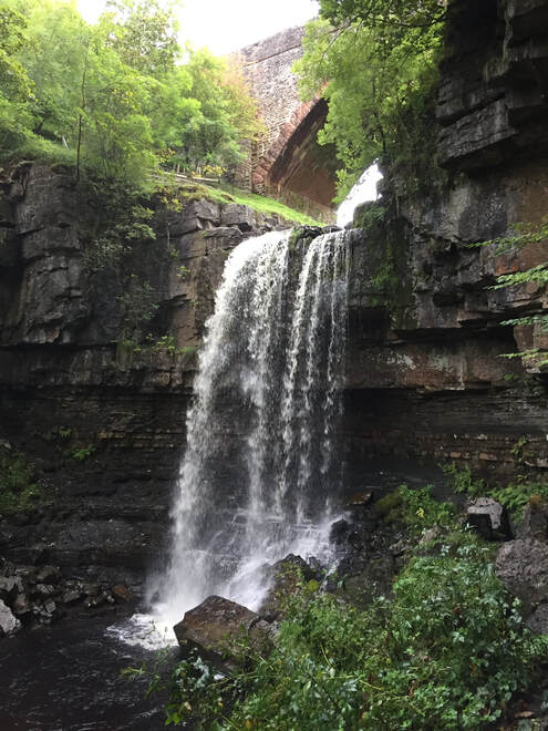 Ashgill Force in Cumbria – a stunning waterfall with harder sandstone forming the top, and softer shale beneath. If you’ve ever been out walking in the hills of the Yorkshire Dales or North Pennines, and taken some time to observe the landscape around you, it’s hard to miss the fact that many of the hills, from Pen-y-ghent to Cross Fell, have flat summits. Looking even closer, you might have noticed that their slopes have a stepped appearance to them. This is no accident, but a direct result of the underlying geology. In places where streams and rivers carve out valleys and gorges, we can begin to see layers in the rocks, laying one on top of the other. Each one is made of sediment (loose material like sand and mud) laid down atop the one below. Some layers took thousands of years to form, while others formed in a matter of hours. The higher up a sequence of rocks you go, the closer you are to the present day, and the further down, the further back in time you go. 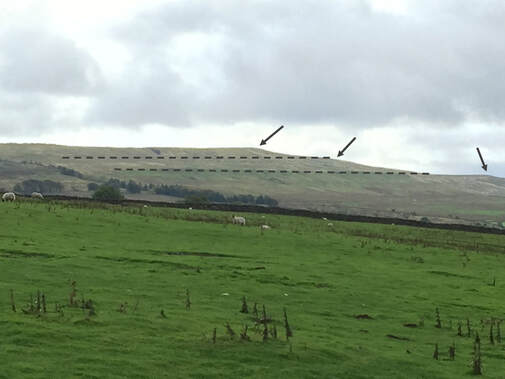 A stepped hillside near the village of Garrigill in Cumbria. Dashed lines highlight the steps. Arrows point out ridges formed of harder rock types. There are three main types of rock you’re likely to come across, and each represents a different kind of environment found in the Carboniferous. Blocky, grey rocks, like those that characterise Malham Cove and Gordale Scar, are limestone. They often have a knobbly texture to them, and were formed at the bottom of shallow, tropical seas, like those found in the Bahamas today. These seas were bursting with life, with vast coral reefs home to fish, snails, brachiopods and crinoids, and their fossils are commonly found in this type of rock. When these creatures died, their remains were mixed with limey mud on the seabed, which over time was solidified to make limestone. Dark, thinly layered rocks are shale (also known as mudstone or siltstone). Perhaps unsurprisingly, these rocks are made from mud and silt. They general represent areas of slow-moving water, where fine particles can slowly settle out of the water. This often happens off-shore, where the water is deeper and calmer. Fossils are less common in this type of rock, but they can occasionally contain very fragile, very flat, plant remains that were washed out to sea. Rough, cream or buff-coloured rocks are sandstone. If you look closely with a hand lens, or even just the naked eye, you can often see the individual sand grains that make them up. We often associate sand with beaches and deserts, but many of the sandstones found in northern England can trace their origins to vast rivers deltas on the shores of an ancient continent. It is within these layers that coal seams can be found, formed from the swampy forests that grew atop the deltas, in an environment not entirely unlike the Amazon Delta or mangrove swamps of the Caribbean today. It’s here that we find many of the most spectacular plant fossils. 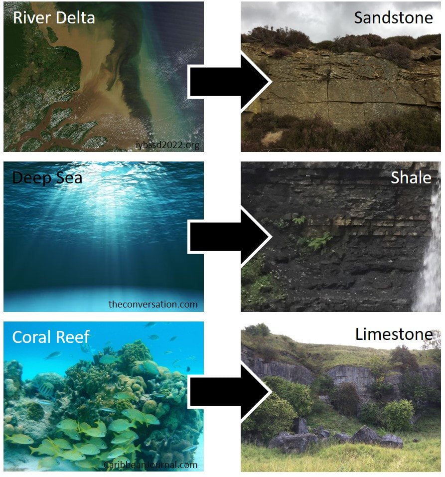 The three main rock types that make up many of the hills of northern England, alongside the environments in which they were formed. But look closer at these rocks and a pattern begins to emerge. There is a sequence: limestone, shale, sandstone, and the sequence repeats, over and over. But why? To change the type of rock layers being laid down, you need to change the environment. After all, the only way to stop a coral reef laying down layers of limestone is to stop it being a coral reef. To get this kind of change you need to change the sea level. In this case, the sea level has to fall, bringing the distant shoreline closer to the pristine coral seas, and with it, sediment carried by rivers. At first the reefs are buried by mud and silt – the finer particles that can drift much further before falling out of the water – laying down layers of shale on top of the limestone. As sea levels continue to fall, and the shoreline grows closer still, larger, heavier particles are laid on top, forming layers of sandstone. Eventually, the river delta has pushed far enough outwards into the sea that its surface is at sea level, and now the coal swamps can begin to develop. But then the sea level rises again, and the limestone-forming coral seas return. 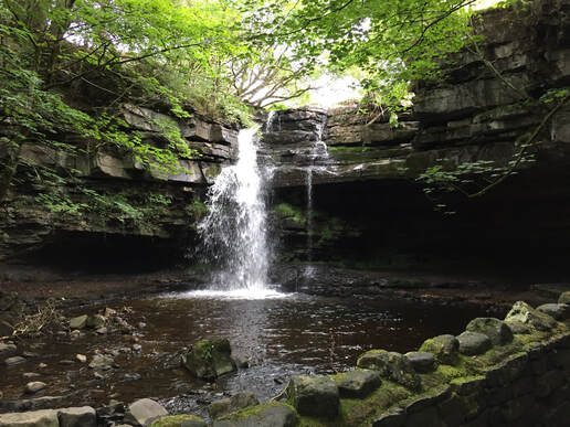 Summerhill Force in Upper Teesdale, County Durham – here the top of the waterfall is made from limestone, while the softer rocks beneath are sandstone and shale. To understand why sea levels were changing, we need to leave behind the warm tropics, and take a brief trip to the poles. Throughout the Carboniferous the world was in the grips of an Ice Age. This seems an odd statement, given that we’ve just talked about warm, coral seas and swampy forests, but at this time in history the UK was much nearer the equator. Ice ages don’t usually cover the whole planet in ice, and even during the more familiar, more recent Ice Age of woolly mammoths and sabre-toothed cats, the tropics remained, well, tropical. There was ice at the poles, as there is today, but ice sheets don’t stay still. In cycles that lasted hundreds of thousands of years, ice sheets wax and wane. As they shrink, sea levels rise, creating more space for coral reefs at the tropics, and when they grow, the sea levels fall, allowing river deltas to push out into the sea. These cycles repeat themselves over and over across the north of England and beyond, and they’re so well known to geologists that they have a name: cyclothems. The softer rocks within these sequences erode more quickly, creating ledges of harder rock. These are responsible for the stepped hills and waterfalls that make the hills of northern England such a spectacular place to visit. Author: Jake Morton
0 Comments
What do a 700-year-old inn, Robin Hood and 340 million years of earth history have to do with a waterfall in Yorkshire? Turns out, quite a bit! A visit to Hardraw Force waterfall can feel like a trip back in time. The historic Green Dragon Inn at the start of the walk to the fall dates to the Middle Ages, and preserves many of its original features. Indeed, sitting beside the roaring fire, under the wooden beams of its roof, you’d be forgiven for expecting the whole band of merry men to come waltzing in at any moment! But there’s a deeper, much older, story to be told here, and to discover it we have to leave behind the comfortable warmth of the fire, head out the back, and journey into the wilds. 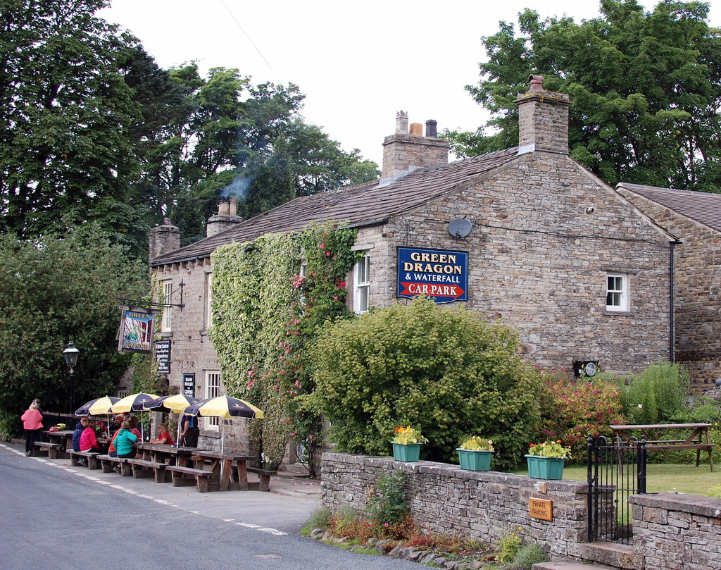 The Green Dragon, starting point for a journey back in time. Photo by Bill Harrison. From here the path follows the Hardraw Beck at a distance, before joining it for the final stretch, up through an enchanting wooded gorge to the fall itself. Hardraw Force is quite the spectacle, with the water of the beck plummeting over a lip of harder rock towards a plunge pool some 30 meters below. This is the largest single drop of any permanent, above-ground waterfall in England, a feet owed to its geology. 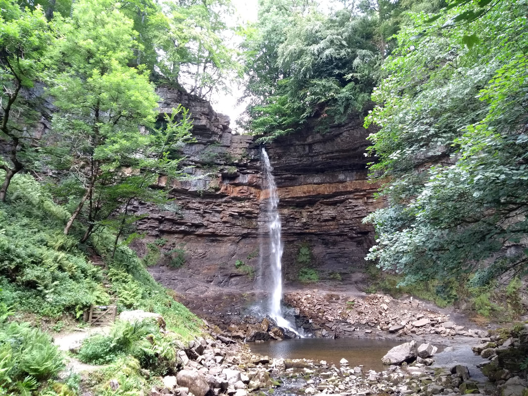 Hardraw Force waterfall, the highest single-drop waterfall in England. The rocks here date to the Visean stage of the early Carboniferous, around 340 million years ago. At that time, Yorkshire was a very different place. A far cry from the wet, temperate climate we enjoy (or not!) today, this land once basked in the warm sunshine of the tropics. And yet, the Earth was in the grips of an Ice Age. Don’t expect to find any woolly mammoths or sabre-toothed cats here though (that more famous glacial period came much later). This was an age long before the first mammals, and almost 100 million years before the first dinosaurs roamed the Earth. As ice sheets waxed and waned at the poles, sea levels in these tropical latitudes rose and fell. At their highest, the region sat below a warm, shallow sea, comparable to the Bahamas of today. These waters were bursting with life, and the remains of long-gone coral reefs form the layer of limestone at the top of Hardraw Force. As sea levels fell and the shoreline crept closer, more and more mud washed in from the land and soon the reefs were buried. This is the origin of the darker mudstones found at the base of the waterfall. Between the limestone and mudstones are thick layers of coarser sandstone, laid down when sea levels dropped even further and yet more sediment washed in the from the land. Vast river deltas developed, like those of the Amazon today, and great swamps flourished atop them. Lurking within these sandstone rocks is evidence of a dragon that once dwelt here. Although, to call the beast a dragon might be a bit of an exaggeration. This dragon didn’t have wings, it certainly didn’t breathe fire, and it probably didn’t even have scales. Our ‘green dragon’ was an early tetrapod, the group of animals from which all land-living vertebrates are descended, including us humans. It was more like a large salamander, heaving its bulky body through this primeval swamp, and leaving footprints in the sand as it went. These trackways, preserved forever in a block of sandstone, provide us a brief glimpse into this lost world. 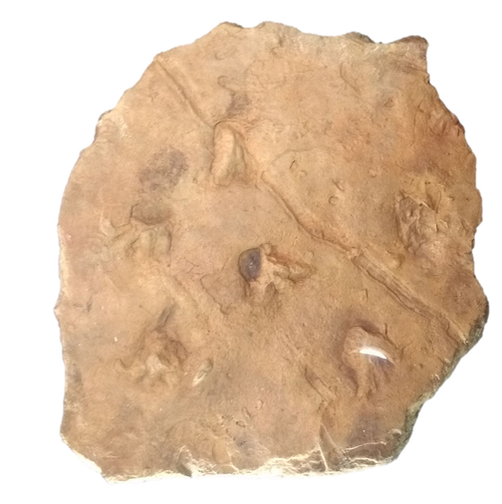 Palaeosauropus sp. trackway. Image of cast on display at Cliffe Castle Museum, Keighley. The story of this specimen is quite an intriguing one. It was found by schoolboy John Chapman around 1966 or 67, who was studying the waterfall and its rocks as part of his geology classes. He gifted it to his teacher, Stuart Maude, who used the specimen in his lessons for a number of years, before eventually donating it to the Natural History Museum in London, where it remains on display to this day. A replica can also be seen on display at Cliffe Castle Museum in Keighley. But what is a trace fossil? And why are they so important to our understanding of past life? When we imagine fossils it’s hard not to picture a wonderfully complete dinosaur skeleton on display in some museum gallery. It’s a nice image, but rarely is it close to the truth. Most fossils are little more than fragments of bone or shell, leaving its discoverer with an often squashed and rarely complete jigsaw to piece together. And then there are trace fossils, not the actual remains of a living thing, but rather something that it left behind through the general activities of its life. This can include coprolites (fossil poo!), eggs shells, or in this case, footprints. While body fossils can tell us what a creature looked like, trace fossils can tell us how it lived. It's quite rare for us to come across a track-maker at the end of its track, so working out exactly whodunnit is often impossible. As such, trace fossils are often given names of their own, in this case Palaeosauropus, which means ‘old lizard foot.’ While no body fossils of our green dragon have ever been found at Hardraw, we do have fossils of similarly aged early tetrapods from elsewhere in the world, from which we can draw comparisons. From them, we can deduce that our trackmaker was 50-75 cm long and likely spent most of its time on land, only returning to the water to reproduce as frogs and salamanders do today. While only footprints, this is the oldest evidence we have for a creature of this kind, one not too far removed from our own ancestor, anywhere in the UK. 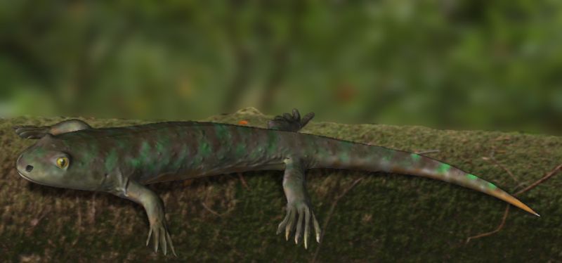 Balanerpeton woodi, a close relative of our green dragon, from Scotland. Illustration by N. Tamura. So, there’s the green dragon and the earth history, but what about the Robin Hood connection? Well, to the best of my knowledge the famous outlaw never encountered a dragon (citation needed), and it’s unlikely he ever visited Hardraw. The Green Dragon Inn does date back to the 13th century though, which is when most of his exploits were said to have taken place, and the 1991 film “Robin Hood: Prince of Thieves” included an infamous scene shot at the waterfall, so I guess there’s that! Author: Jake Morton References
Bird HC, Milner AC, Shillito AP and Butler RJ, 2020. A lower Carboniferous (Visean) tetrapod trackway represents the earliest record of an edopoid amphibian from the UK. Journal of the Geological Society, 177, pp. 276-282. Milner AR and Sequeira SEK, 1994. The temnospondyl amphibians from the Visean of East Kirkton, West Lothian, Scotland. Transactions of the Royal Society of Edinburgh: Earth Sciences, 84, pp. 331-361. Near the Yorkshire-Lancashire border, a domineering peak rises from the valley floor and looms over the skyline for miles around. The year is 1612, the reign of the paranoid King James I of England. Ten women and two men stand accused of using witchcraft in order to commit murder. These people were not your broomstick-riding, pointed-hat wearing, green-skinned witches of popular media, they were most likely village healers, skilled in the use of herbs and traditional remedies. These skills however left them open to accusation of witchcraft, which is rather a problem when there are deep running family feuds in the area. All but one of these supposed witches were hanged for their “crimes” but their legend lives on. The area where we lay our scene is, of course, Pendle Hill. 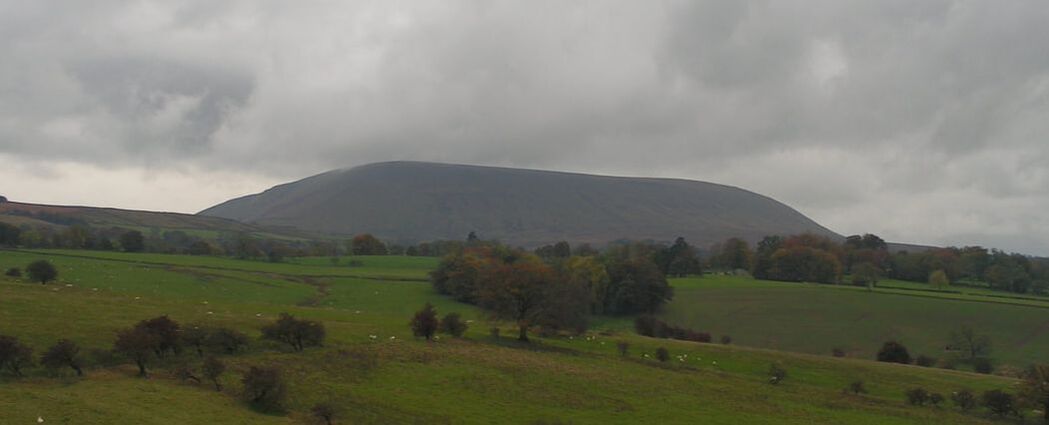 The east face of Pendle Hill 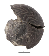 Goniatite collected from a stream near Pendleton. Held by the Manchester Museum, photograph from GB3D. Goniatite collected from a stream near Pendleton. Held by the Manchester Museum, photograph from GB3D. Pendle Hill itself rises rather dramatically out of the Ribble Valley and is an area of great geological interest – it even gives its name to a specific time interval in the Carboniferous (the Pendleian, approximately 329 to 328 million years ago). The valley floor is dominated by limestone rocks with patches of reefs from which some rather lovely fossils have been found, such as these goniatites. These rocks would have been formed in a shallow and warm sea with very little sediments being washed in from the land. The rocks overlaying the limestone which make up the hill show a marked change in environment – the dark mudstone suggests a sudden influx of increased mud and sediment from land. These rocks are known as the Bowland Shale. Mudstones don’t usually make big hills though and Pendle Hill is no exception; the upper flanks of the hillside show another change in environment and are dominated by hard-weathering sandstone beds. These can be seen nicely in the Nick of Pendle Quarries along the roadside towards the northeast of the hill, where conveniently there happens to be a carpark! 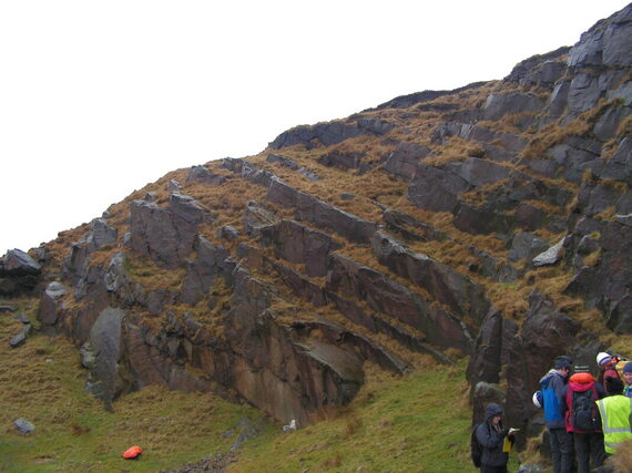 Nick of Pendle Quarries, cold and wet students for scale. These sandstones are similar to the iconic Millstone Grit rocks of the nearby Pennines although their origin is quite different. Whereas the Millstone Grit was formed by the delta of a large river, the Pendle Grit is the product of those rivers dumping this sand out to open sea. Every now and again those sands would collapse and cascade into the deep mudstone oceans. These colossal cascades of sediment are known as turbidity currents – imagine a huge underwater avalanche made of sand, silt and mud and you’re thinking along the right lines. These currents flow down underwater canyons or channels and spill out to make big sand lobes across the seafloor. The catastrophic origin of these sandstones is suggested by several lines of evidence. The underside of the beds show scour marks made by the erosion of the sediments that were already there. Sometimes these erosive features are quite big and whole beds of sediment can be removed in areas – it depended on how much energy the flow had! These hollows were quickly filled in by sand from the flow, making a natural cast of the scour. 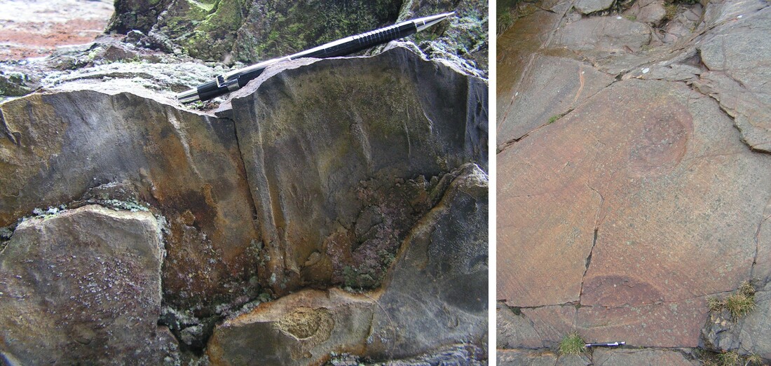 Left: scour marks preserved as casts on the underside of a sandstone bed. Right: scour marks made into a sandstone bed, the overlying sandstone has been removed probably during quarrying allowing a top-down view of the scours. Pencil for scale. On the southwest side of Pendle Hill there are some good internally scoured surfaces, these formed within a single flow when the current cannibalised the sandstones during their deposition, ripping them back up just as they were laid down! 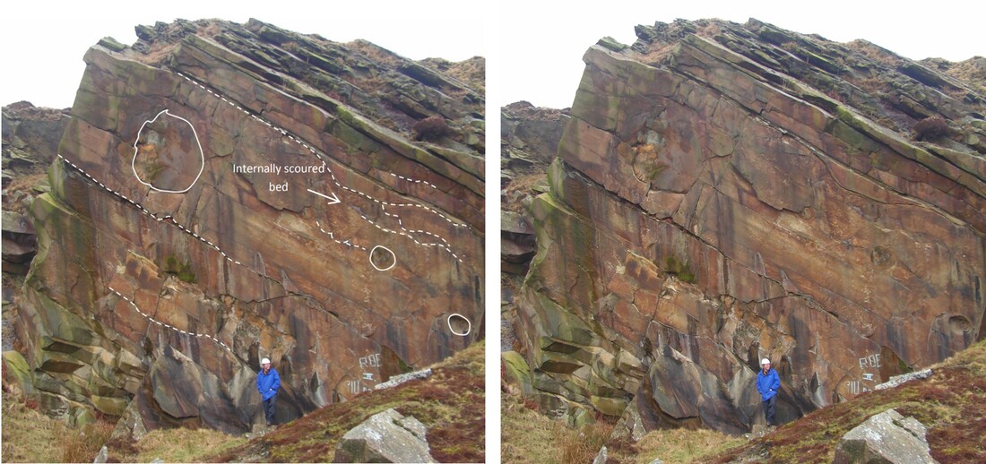 Wiswell Quarry, internally scoured levels are highlighted with dashed lines, solid lines are showing large concretions – a mineralization feature that formed after deposition of the sandstone. 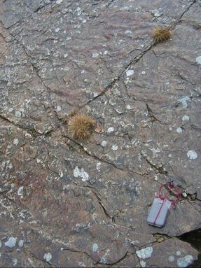 Ripple marks in the upper surface of a sandstone bed. Compass for scale. Ripple marks in the upper surface of a sandstone bed. Compass for scale. Eventually these catastrophic sand avalanches begin to lose their momentum and finer sands can be deposited. These tend to show ripples, and by taking a compass bearing of these you can get an idea of which way turbidity current was flowing. Once the current had passed through there would still be some of the finest particles of sediment left floating around in the water, this silt and mud slowly settled out and draping the ripples and burying them. Between the northeast edge or the Hill at Nick of Pendle and the southwest at Wiswell Quarry there is a change in the amount of sand versus silt and mud. This is because turbidity currents tend to dump their heavy sands pretty quickly. At the Nick of Pendle there are lots of thick sandstone beds which suggests you were closer to the mouth of the river, whereas if you go over to the Wiswell quarries you are further out to sea and so will see thinner sandstones, more ripples and a lot more silt which can be carried further. Pendle Hill preserves only a small section of these vast seafloor sand lobes, with much of them having been removed by uplift and erosion and then carved into the hill we see today by the advance of glaciers during the ice age. 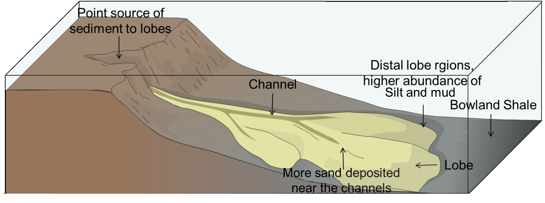 Block model showing the sand lobes produced by turbidity currents projecting out into the mudstones of the Bowland Shale. Pendle Hill is a great example of how landscapes hold such a wealth of history, both human and deep time. This great Lancashire landform has seen many dramatic events – from the grisly tale of the persecution of the Pendle witches to huge underwater landslides cascading down into the deep dark ocean floor. Author: Jed Atkinson
The same was true of prehistoric sharks, although some took this curved conveyer belt tooth row to an extreme! The ‘whorl toothed sharks’ were an extremely unusual group that swam in the oceans from 323 to 247 million years ago (the earliest dinosaurs appear on land at around 250 million years ago).
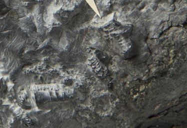
Helicoprion is well-known from fossils from North America and Russia, but few people are aware of its Yorkshire ancestor! One of the earliest whorl toothed sharks is from Carboniferous aged rocks (around 320 million years old) near Brockholes just south of Huddersfield. This beautiful specimen was described as a new species, Edestus newtoni, in 1916. 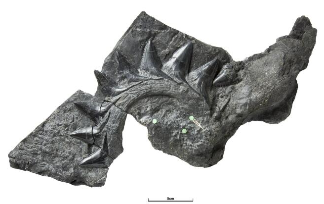 Edestus newtoni from the collections of the British Geological Survey (GSM 28346), photo from GB3D Fossils Edestus is unique in having a curved tooth row on both the upper and lower jaw – as our Huddersfield specimen has only one jaw it has been suggested that it might belong to a different genus, Lestrodus, instead (Tapanila et al 2019).
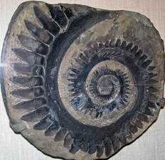
The function of the tooth whorl of Helicoprion, Edestus, and their relatives has been the subject of many different artistic reconstructions throughout the decades – was it the upper jaw? Lower jaw? Both jaws? Spiky fin spine? Could the tooth row unroll like a whip? These different interpretations were famously summarised by the artist Ray Troll: 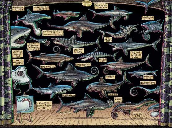 Artwork by Ray Troll It is now fairly accepted that the tooth whorl formed part of the lower jaw in these sharks, however variation in tooth whorl shape between different species means there is still much debate about how these animals fed. Research published in 2015 by Ramsay et al. analysed the forces on the tooth whorl of Helicoprion and found that it was well adapted to eating animals like ammonites with a soft body in a hard shell. The circular nature of the tooth row creates forces on the prey in different directions simultaneously – the front teeth would push the shell away whilst the back teeth pull and cut the soft body into the mouth. Other interpretations include the outer teeth slashing prey, the upper and lower jaw cutting prey like scissors, or the bottom jaw moving backwards and forwards like a saw (Itano 2019). The tooth whorl of Edestus highlights the ever-changing nature of palaeontological science, constantly refining and adapting ideas based on new techniques and new discoveries. How do you interpret these fossils? What was the function of these teeth? Come by the Fossils in t’Hills stall at one of our upcoming events and have a go at your own reconstruction! Author: Rebecca Bennion References
|
Archives
February 2024
Categories
All
|
 RSS Feed
