|
Taking some time to look at an outcrop of rock can be like taking a trip back in time. Our human brains can barely comprehend the span of a century, so it can be truly mind-boggling to think that a small cliff-face, little more than a few meters tall, could represent many thousands of years of our planet’s history… Here at Fossils in t’Hills we spend a lot of time talking about the Carboniferous Period. It’s a term some of our readers will know well, but for others one that might require a little more explanation than we’ve given it in the past. This month we’re going to shine a little light on the Carboniferous, and its relevance to the rocks, fossils and landscapes of northern England. To put the Carboniferous Period into context we need to dive into what geologists call ‘deep time’. We can get a better understanding of deep time by thinking of our planet’s history as a book. This monstrous tome has 450 pages, with each representing around 10 million years of history. Unfortunately, the first 300 pages have been mostly torn out, screwed up, folded, set on fire, and what’s left stuffed back in between the later pages. But that’s alright; for those of us with a keen interest in fossils, it’s really only the last 60 pages that matter! There’s a lot packed into this story, with a wide cast of characters and many twists and turns. To help make sense of it all, geologists divide the plot into chapters called eras and periods. One of these periods is called the Carboniferous. The Carboniferous Period spans around 359 million years ago to around 299 million years ago, meaning it’s covered on pages 414 through to 420 (concluding a full six pages before the dinosaurs appear). The word ‘Carboniferous’ means ‘carbon-bearing,’ a name it owes, in part, to northern England, where coal has been mined for centuries. But aside from fuelling (literally) the Industrial Revolution, the rocks of northern England are responsible for the incredible landscapes that make this part of the country so special. 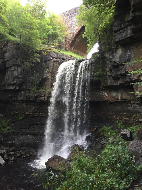 Ashgill Force in Cumbria – a stunning waterfall with harder sandstone forming the top, and softer shale beneath. If you’ve ever been out walking in the hills of the Yorkshire Dales or North Pennines, and taken some time to observe the landscape around you, it’s hard to miss the fact that many of the hills, from Pen-y-ghent to Cross Fell, have flat summits. Looking even closer, you might have noticed that their slopes have a stepped appearance to them. This is no accident, but a direct result of the underlying geology. In places where streams and rivers carve out valleys and gorges, we can begin to see layers in the rocks, laying one on top of the other. Each one is made of sediment (loose material like sand and mud) laid down atop the one below. Some layers took thousands of years to form, while others formed in a matter of hours. The higher up a sequence of rocks you go, the closer you are to the present day, and the further down, the further back in time you go. 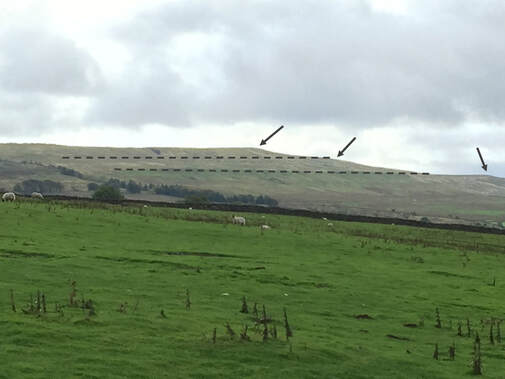 A stepped hillside near the village of Garrigill in Cumbria. Dashed lines highlight the steps. Arrows point out ridges formed of harder rock types. There are three main types of rock you’re likely to come across, and each represents a different kind of environment found in the Carboniferous. Blocky, grey rocks, like those that characterise Malham Cove and Gordale Scar, are limestone. They often have a knobbly texture to them, and were formed at the bottom of shallow, tropical seas, like those found in the Bahamas today. These seas were bursting with life, with vast coral reefs home to fish, snails, brachiopods and crinoids, and their fossils are commonly found in this type of rock. When these creatures died, their remains were mixed with limey mud on the seabed, which over time was solidified to make limestone. Dark, thinly layered rocks are shale (also known as mudstone or siltstone). Perhaps unsurprisingly, these rocks are made from mud and silt. They general represent areas of slow-moving water, where fine particles can slowly settle out of the water. This often happens off-shore, where the water is deeper and calmer. Fossils are less common in this type of rock, but they can occasionally contain very fragile, very flat, plant remains that were washed out to sea. Rough, cream or buff-coloured rocks are sandstone. If you look closely with a hand lens, or even just the naked eye, you can often see the individual sand grains that make them up. We often associate sand with beaches and deserts, but many of the sandstones found in northern England can trace their origins to vast rivers deltas on the shores of an ancient continent. It is within these layers that coal seams can be found, formed from the swampy forests that grew atop the deltas, in an environment not entirely unlike the Amazon Delta or mangrove swamps of the Caribbean today. It’s here that we find many of the most spectacular plant fossils. 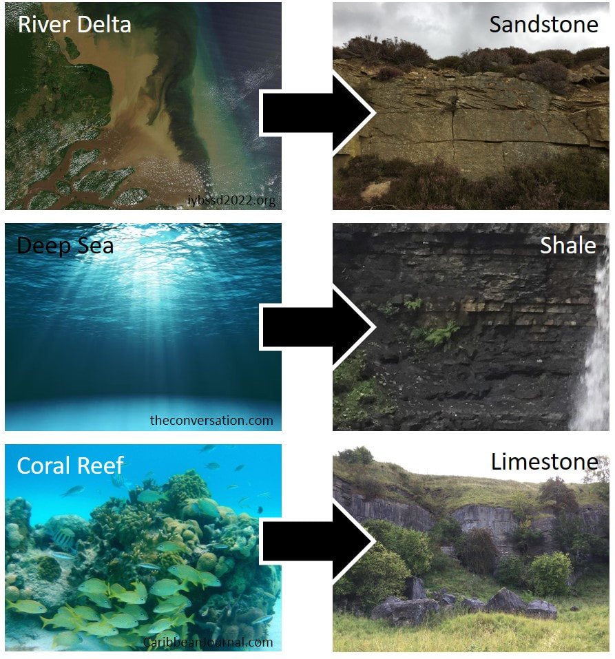 The three main rock types that make up many of the hills of northern England, alongside the environments in which they were formed. But look closer at these rocks and a pattern begins to emerge. There is a sequence: limestone, shale, sandstone, and the sequence repeats, over and over. But why? To change the type of rock layers being laid down, you need to change the environment. After all, the only way to stop a coral reef laying down layers of limestone is to stop it being a coral reef. To get this kind of change you need to change the sea level. In this case, the sea level has to fall, bringing the distant shoreline closer to the pristine coral seas, and with it, sediment carried by rivers. At first the reefs are buried by mud and silt – the finer particles that can drift much further before falling out of the water – laying down layers of shale on top of the limestone. As sea levels continue to fall, and the shoreline grows closer still, larger, heavier particles are laid on top, forming layers of sandstone. Eventually, the river delta has pushed far enough outwards into the sea that its surface is at sea level, and now the coal swamps can begin to develop. But then the sea level rises again, and the limestone-forming coral seas return. 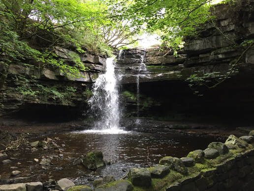 Summerhill Force in Upper Teesdale, County Durham – here the top of the waterfall is made from limestone, while the softer rocks beneath are sandstone and shale. To understand why sea levels were changing, we need to leave behind the warm tropics, and take a brief trip to the poles. Throughout the Carboniferous the world was in the grips of an Ice Age. This seems an odd statement, given that we’ve just talked about warm, coral seas and swampy forests, but at this time in history the UK was much nearer the equator. Ice ages don’t usually cover the whole planet in ice, and even during the more familiar, more recent Ice Age of woolly mammoths and sabre-toothed cats, the tropics remained, well, tropical. There was ice at the poles, as there is today, but ice sheets don’t stay still. In cycles that lasted hundreds of thousands of years, ice sheets wax and wane. As they shrink, sea levels rise, creating more space for coral reefs at the tropics, and when they grow, the sea levels fall, allowing river deltas to push out into the sea. These cycles repeat themselves over and over across the north of England and beyond, and they’re so well known to geologists that they have a name: cyclothems. The softer rocks within these sequences erode more quickly, creating ledges of harder rock. These are responsible for the stepped hills and waterfalls that make the hills of northern England such a spectacular place to visit. Author: Jake Morton
0 Comments
|
Archives
February 2024
Categories
All
|
 RSS Feed
